


Descripción de iNavX - Sailing & Boating Navigation, NOAA Charts
** Navigate Confidently, Navigate with iNavX - the world's #1 Marine Navigation App
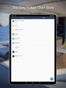
** And, the ONLY app to provide all your favorite charts from your favorite chart providers
“Editor's Choice” - Practical Sailor
"The Standard" - Cruising Magazine
"Must Have List" - Cruising World
Trusted internationally by casual and professional sailors, cruisers, boaters, fishermen, and divers.
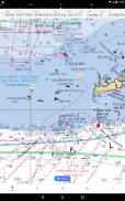
Downloads iNavX TODAY and automatically receive a complimentary copy of the official and up-to-date high resolution NOAA RNC United States marine raster charts.
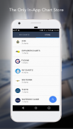
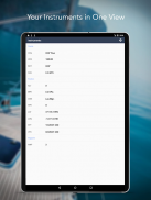
iNavX is the ONLY APP to give you access all of your favorite charts directly through the app. Fully enabled with one-touch purchase and download, iNavX gives users the most streamlined access to the broadest set of marine charts and maps from multiple providers.
• NAVIONICS
• DELIUS KLASING
• EXPLORER
• BLUE LATITUDE
• THEYR WEATHER
• WATERWAY GUIDE
• ... and more
iNavX takes handheld marine navigation to the next level.
• Anglers: Discover new fishing spots by scouting out deep holes and inlets. Locate the best fishing conditions by identifying cold fronts. Save your best fishing spots with the only app that offers unlimited markers.
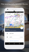
• Sailors: Plan great routes with waypoint and route management. Have proactive sail management with GRIB weather forecasts. Then keep watch with integration with external AIS receivers and responders. And remember great locations by geotagging photos.
• Boaters: Stay up to date on boating conditions with weather forecasts that includes currents, winds, and swells. Then save and share great boating routes to share with the track log.
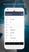
ADVANCED FEATURES - iNavX is the most feature rich app available
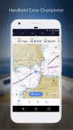
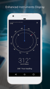
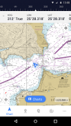
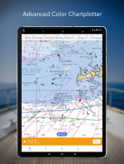
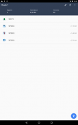
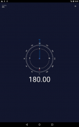
Advanced Chart Plotter
• Plot your position in real-time using your device's built-in GPS
• Easily pan, zoom, and rotate charts (including course up)
• Print a detailed chart to use in combination with the app
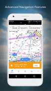
Advanced Navigation
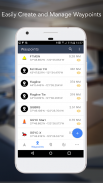
• Create waypoints and plan routes to navigate between them
• Track log allows you to record your actual route
• Import/Export data in KML (Google Earth) or GPX format
REVIEWS
“iNavX is the original and still the best navigation app.” – Practical Sailor
“The most full-featured navigation app around and viewed by many as the standard” – Sail Magazine
"The #1 recommended marine charting app" - iMarineApps
** Navegue con confianza, navegue con iNavX, la aplicación de navegación marina número 1 del mundo
** Y, la ÚNICA aplicación para proporcionar todos tus gráficos favoritos de tus proveedores de gráficos favoritos
“Elección del editor” - Practical Sailor
"The Standard" - Revista de crucero
"Must Have List" - Cruising World
Confiado internacionalmente por marineros casuales y profesionales, cruceros, navegantes, pescadores y buzos.
Descargue iNavX HOY y reciba automáticamente una copia de cortesía de las tablas de ráster marinas de Estados Unidos de NOAA RNC de alta resolución, oficiales y actualizadas.
iNavX es la ÚNICA APLICACIÓN que le permite acceder a todos sus gráficos favoritos directamente a través de la aplicación. Totalmente habilitado con la compra y descarga de un solo toque, iNavX brinda a los usuarios el acceso más ágil al conjunto más amplio de mapas y mapas marinos de múltiples proveedores.
• NAVIONICS
• DELIUS KLASING
• EXPLORADOR
• LATITUD AZUL
• EL TIEMPO
• GUIA DE AGUAS
• ... y más
iNavX lleva la navegación marítima de mano al siguiente nivel.
• Pescadores: descubra nuevos lugares de pesca explorando hoyos y entradas profundos. Localiza las mejores condiciones de pesca identificando frentes fríos. Guarda tus mejores lugares de pesca con la única aplicación que ofrece marcadores ilimitados.
• Marineros: planee grandes rutas con waypoint y gestión de rutas. Disponer de una gestión proactiva de la vela con previsiones meteorológicas GRIB. Luego vigile con la integración con receptores y respondedores AIS externos. Y recuerda los grandes lugares al etiquetar geográficamente las fotos.
• Navegantes: manténgase actualizado sobre las condiciones de navegación con pronósticos meteorológicos que incluyen corrientes, vientos y oleajes. Luego guarde y comparta excelentes rutas de navegación para compartir con el registro de seguimiento.
CARACTERÍSTICAS AVANZADAS: iNavX es la aplicación más rica en funciones disponible
Plotter gráfico avanzado
• Marque su posición en tiempo real con el GPS incorporado de su dispositivo
• Paneo, zoom y rotación de gráficos fácilmente (incluido el curso hacia arriba)
• Imprima una tabla detallada para usar en combinación con la aplicación
Navegación avanzada
• Crea puntos de referencia y planifica rutas para navegar entre ellos
• El registro de seguimiento le permite grabar su ruta real
• Importar / Exportar datos en formato KML (Google Earth) o GPX
REVISIONES
"INavX es la aplicación de navegación original y aún mejor". - Practical Sailor
“La aplicación de navegación más completa y vista por muchos como la norma” - Sail Magazine
"La aplicación de cartografía marina recomendada # 1" - iMarineApps
iNavX - Sailing & Boating Navigation, NOAA Charts - Versión 1.6.4
(31-10-2023)iNavX - Sailing & Boating Navigation, NOAA Charts - Información de APK
Version de la app: 1.6.4Paquete: com.gpsnavx.iNavXÚltima versión de iNavX - Sailing & Boating Navigation, NOAA Charts
Apps en la misma categoría
Quizá también te interese...


